Showing posts with label Natural Vegetation. Show all posts

Friday, December 23, 2011

The Threat of Logging in the Philippines

Kalamansig in Sultan Kudarat, Mindanao, houses a populace of 48,000 people. Decades of unsustainable practices and illegal tree logging had taken tolls on their imagelivelihoods and food security. About half of Kalamansig’s residents were engaged in illegal logging inside its 40,000 hectares (ha) of forestlands. Significant plots of the forestlands were converted into farmlands. These activities attributed to the drastic decline of Kalamansig’s forest cover from 36,705 ha in 1987 to only 10,000 ha in 2003. The annual clearance of forestlands brought about approximately 2,000 lowland residents to fall as victims to flash floods each year during the wet season.

The recent Typhoon Mashi that battered Mindanao on December 17, 2011, had raised concerns on whether illegal logging had been responsible for exacerbating the impacts that the typhoon entailed. The Philippines President Benigno Aquino ordered an investigation to check out if violations to the logging ban had aggravated the damages inflicted by Typhoon Washi. On Febrauary 2010, President Aquino III declared a total log ban in the Philippines, but illegal logging activities persisted in northern Mindanao. Aquino’s Executive Order 23 discontinued the issuance of permits to any individuals to log trees across the Philippines, in response to widespread flooding and landslides in Mindanao, Eastern Visayas and Bicol regions. Under the executive order, the environment department is prohibited from distributing logging permits and contracts in all natural and residual forests. The prohibition also includes the renewal of tree-cutting permits in all forests across the Philippines.

image Rampant logging activities in the mountainous regions of northern Mindanao  could have caused the heavy flooding that Typhoon Washi entailed. The dwindling forest covers in the area failed to decelerate the flow of rainwater downstream into rivers, attributing to flash floods in the low lying areas. As of  December 18 afternoon, the National Disaster Risk Reduction Management Council (NDRRMC) revealed that a total of 332 people were pronounced dead due to flash floods caused by Typhoon Washi. The latest tally on December 21 showed a total of 1,102 people who were confirmed dead, including 650 in Cagayan de Oro and another 283 in Illigan city. The rest of the death tolls were logged in other southern and central provinces. Many victims were swept away by huge logs that were rolled down from denuded mountains facing the two cities that were badly hit by the typhoon. Experts highlighted that unmitigated logging and deforestation were responsible for soil erosion and triggered mudslides. Tampering with the watersheds and forests have revealed the vulnerability of the people in the Philippines during such events. Efforts in cracking down on illegal logging would have to be stepped up in order to prevent further disastrous impacts in the future.


References:

Wednesday, February 23, 2011

Disappearing forests in Southeast Asia

image

Map above shows the extent of disappearing and degraded forests in Southeast Asia region.

Southeast Asia (SEA) is confronted with the highest deforestation rates in the world and increasing economic growth in the region further intensifies the pressure on these forests. Indonesia, the Philippines and Malaysia are some countries that face the serious problems and consequences of deforestation.

Indonesia has observed the removal of large tracts of its forests. In the 1950s, more than 85% of the country were constituted of forested lands and it is dropped to below 47% at present day. Main areas subject to deforestation include Jambi, South Sumatra, West and Central Kalimantan, Riau and Papua of East Indonesia. However, there is inability to produce accurate maps to show the exact extent of forests that succumb to deforestation due to factors such as incomplete information obtained from theimage local provinces, inaccessibility of the remote and rugged terrain, and heavy cloud cover that persists throughout the year which does not permit clear satellite imageries to be obtained. Deforestation in Indonesia kick-started in the 1960s when the timber exporting industry was seen as a sector that was capable of reaping in profits within a short period of time. Illegal logging soon become out of control. The onset of the late 1990s saw the clearance of around 3 million hectares (ha) of forested lands annually. Attempts to curb or ameliorate deforestation was an uphill task given the decentralised approval of land permits and corruption issues that hindered the cracking down on deforestation. Lax law enforcement aggravated the problem further.Deforestation also brought about a series of concomitant environmental and social problems. With the destruction of their natural habitats, the population of orang utans in Borneo fell by more than 50% over the past 50 years and those currently found in Sumatra was only 20% of that 75 years ago. Certain deforested lands saw increased instances of flooding as these lands which had been cleared to give way to plantations had lower water retention capacity relative to forest trees. Furthermore, mass logging undertaken by timber and oil palm companies have displaced the Orang Rimba people who live in Sumatra’s Jambi forest. Despite initiatives to conserve forests via the Untied Nations scheme known as Reducing Emissions from Deforestation and Forest Degradation (Redd),the success of such an initiatives remains doubtful and the people are struggling to comprehend the operations of such a scheme. In addition, it is an imperative to have an institutional framework, legislations and decision community to be formed to determine the groups who are able to enjoy the financial incentives upon the conservation of forest lands.

The Philippines banned timber harvesting on February 1, 2011image to prevent detrimental consequences of logging, which include flooding and landslides. Such a move came in response to the weeks of torrential rain that emptied in the region, causing severe floods and forcing more than 1 million people into evacuation centres and damaged $35 million worth of crops and property. The Philippines is the fourth most threatened forest lands. Since the 1950s, it possessed 15 million ha of forests, which made up 50% of its land mass. However, by 1997, there were only 5.4 million ha. The initiation of reforestation programmes raised the amount of forested lands to 7.2 million ha. Logging is now only lawful in plantations, which cover 300,000 ha of forested land. The profitable nature and expansion of industries involving furniture and woodcrafts led to increased deforestation rates. There is substantial evidence pointing to deforestation being responsible for landslides and flooding incidences over the years. In November 1991, flash floods took more than 6,000 lives when the the Filipino town of Ormon had debris such as logs and shipping containers packed with cut timber flushed down a mountainside. Enforcing the ban on logging in natural forests would be a challenge, given the problem of serious shortage of forest rangers, with only one ranger patrolling 4,000 ha of forested land. The wood industry disapproves of the ban and warned against high numbers of job losses as about 650,000 people are engaged in wood processing activities, given the nation’s growing dependence on timber imports.  

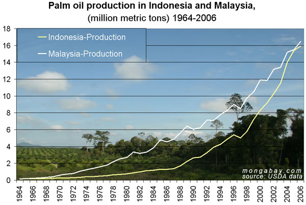
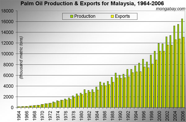
Malaysia has been suffering from landslides due to the felling of trees as tonnes of logs were flushed into Sarawak rivers in a landslip in 2010. This led to the Rajang River being impassable for several days. Satellite images revealed that large swathes of peatland were converted into oil palm plantations. Around 10% of Sarawak’s land is made up of peatland. Peatland refers to wetlands with soil comprised of organic matter and it is permanently waterlogged. image Clearance of peatlands is an area of serious concern as they release large amounts of carbon dioxide and bring about global warming. Malaysia is the world’s second largest producer of oil palm after Indonesia and it is responsible for the production of around 40% of global oil palm supplies and the industry is valued at S$25 billion. Around 20% of Malaysia’s oil palms sits on peatland but that in Sarawak is made up of 44%. Reduced availability of land in Peninsular Malaysia led to the housing of oil palm plantations in Sarawak, East Malaysia, which sees the strong growth of oil palm companies being established. Drained peatland is also easily combustible during dry periods, making it a fire hazard and a contributor to haze in the SEA region. Besides global warming concerns, peatlands is home to a rich diversity of flora an fauna species, causing the urgent need to conserve these lands. Peat land forests in Malaysia houses significant numbers of endangered species such as the Borneo pygmy forest, the Sumatran rhino and the Bornean clouded leopard. Waters of these peat swamps have the highest numbers of freshwater fish species in the need. Hence, clearance of peatlands would further threaten the survival of these species, drawing the attention of many conservationists.


References:

Tuesday, December 21, 2010

Nature Reserves and Ecotourism

Singapore and Malaysia are engaging in discussions over the establishment of an eco-tourism project where 3 gazetted nature sites in Johor – Pulau Kukup, Tanjung Piai and Sungei Pulai, could be marketed together with Sungei Buloh wetlands in Singapore. Such an initiative seeks to ride on the burgeoning eco-tourism market, which is increasingly popular.


The 138 hectares Sungei Buloh Wetland Reserve was gazetted as a nature reserve on January 1, 2002 and was also recognised as a site of international importanceimage for migratory birds. It is located in the northwest part of Singapore and dominated by tidal  mudflats and mangrove systems. The area now houses a variety of flora and fauna, with more than 220 species of birds. the migratory birds are attracted to the exposed mudflats in the abandoned prawn ponds and water levels in the mudflats are regulated by sluice gates so as to maintain some exposed mudflats at all times to attract waders and shorebirds. As 140,000 visitors visited the area in 2009, there have been concerns as to protect the site from excessive public exposure. In order to reduce the crowd entering the area and maintain the balance of the ecosystems, the authorities are planning to cap the entrance of visitors to the area at 100,000 by diverting the crowd to a new 38 hectares park that would surround the reserve.


Sungei Pulai spans 9 imagehectares and is the second largest  mangrove site in the Johor state and gazetted by the government in 1923. It houses a rich diversity of flora and fauna such as the Avicennia lacenta, smooth otter and flat headed cat. It also houses the threatened bird species such as the mangrove pitta. It is home to about 24 ‘true’ mangrove plant species as well as 21 more mangrove-associated species, which demonstrates a high species richness in the area. It plays important ecological functions such as the retention of sediments and nutrients and the removal of toxicants. Furthermore, it harbours economically viable timber resources and fisheries and acts as a form of coastal protection against strong wind and sea currents. Areas of concern would include the entrance of illegal loggers in the area, clearance of natural vegetation and land reclamation. It is estimated that between 1980 and 1990, 12% of the country’s mangrove forests disappeared. Hence, there is a need to step up efforts to protect the mangrove areas and concomitantly preserve the diversity of flora and fauna species in these areas.


Tanjung Piai is seated at the image southern tip of Malaysia and the Tanjung Piai National Park is home to more than half of the 40 known freshwater mangrove species of the world. It supports many threatened species such as the pig tailed macaque and mangrove pitta. Tanjung Piai covers 526 hectares of mangroves and another 400 hectares of inter tidal mudflats. Mudflats are soft and muddy soil with high salt content and low oxygen levels. However, they are subject to hot and dry conditions. It forms the only mangrove corridor connecting Pulau Kukup and Sungei Pulai wetlands. The site was conferred the status of a state park for eco-tourism by the Johor government, such that it would be funded by S$2.15 million annual budget that is shared with 4 other such parks. In 2002, the park was open to the public. The park was declared a Ramsar Site on 31 Jan 2003. and gazetted as a Johor National Park on 26 Feb 2004. Bunds were created along the west and east coasts of Tanjung Piai to protect farmlands from inundation by salt waters. Tanjung Piai is subject to erosion from the tidal currents, with the coastal mangrove fringes being reduced to 50m at certain stretches.


Pulau Kukup is an uninhabited island located at the south-western region imageof the Johor state and about 1 kilometre offshore from the mainland town known as Kukup Laut.  The island is about 647 ha in size with an 800 ha intertidal mudflat srurounding the island. The island was gazetted as a State Park in 1997 and  designated as a Ramsar site of Malaysia in 2003. Pulau Kukup is a popular tourism site seeing high flow of tourists from neighbouring countries like Singapore and Indonesia visiting Kukup town for its famous seafood annually. Pulau Kukup is endowed with a rich diversity of flora and fauna species as there are 30 species of true mangrove and associated species, 12 wildlife species, 11 waterbird species include the Vulnerable Lesser Adjutant Stork. Pulau Kukup was officially gazetted as a State Park under the jurisdiction of the Johor State Park Corporation on March 27, 1997. In order to be declared as a Ramsar site, there are several guiding criteria which include high biodiversity of mangrove species in small areas, important bird areas and the presence of unique ecological wetlands. The objective of turning this island into a state park was to promote preservation of this habitat in Peninsular Malaysia, promote the eco-tourism sector and to serve as avenues for the conducting of researches and field studies.


With the talks of developing a cross border tourist attraction involving the Sungei Buloh wetlands and the 3 other gazetted nature sites in the Johor state of Malaysia, researchers and nature enthusiasts welcome such a move as they see that it is feasible economically and ecologically. Protecting wetlands that are divided by small stretches of water could also slow down the rate at which mangroves are lost and enable birds to migrate periodically. Despite the interest to promote eco-tourism, there must be care and attention to the number of visitors to these nature sites so as to avoid upsetting the balance of such ecosystems,

References:

Tuesday, December 14, 2010

2010 Sumatran Forest Fires

Satellite pictures on October 19, 2010, exhibited the presence of 202 hot spots in Sumatra, indicating the areas where Indonesia farmers and plantation companies imagehad started fires to clear large tracts of the forests to prepare the lands for the crop-planting season.  Since the early 1990s, such a practice led to the development of a choking and smoky pall that engulfs Singapore and Malaysia. The prevailing winds originating from the southwes t direction helped to carry the smoke to Singapore. The hot and dry weather in Riau further aggravated the haze problem in 2010 as it was a challenging task to contain the forest fires.

With the presence of companies owning plantations, recurrence of such haze would persist. Several giants in the oil palm and the pulp and paper industry possess concessions imagedirectly or through their subsidiaries throughout the Riau province. These big companies are influential in causing farmers to shift towards the cultivation of lucrative oil palm from the previous traditional crops. With the entrance of these big companies, infrastructures such as roads and canals, hence further attracting local farmers to engage in oil palm cultivation as the latter can tap on the available infrastructures brought in by the giant companies. However, with the absence of close monitoring and regulation by the local authorities who are involved in the issuance of permits for cultivation, attributing to local farmers using the available lands in an unsustainable, destructive manner.

Activists have also put the blame on big companies as it is realised that some of the fires took place in the vicinity or within the plantations. Large companies generally conform to the ‘no-burning policy’ in Indonesia by hiring contractors to perform land clearance and they subsequently employ villagers who ignited the fires. Activists are also pushing the government to step up the measures to prevent such forest fires. However, the local government has only reacted to the fires but not prevent their occurrences at present. The problem is even more sticky with the coincidence that the location of the hot spots turned out to be the same annually.

With the land clearance practices bringing frequent reports of haze in the Southeast Asian region and affected public health and the economies of neighbouring countries. In order to better tackle the situation, regional cooperation is essential. In addition, the national level could introduce implementations such as putting a ban of cultivating in areas where the peat is more than 3 metres deep and revoke the licences of landowners who are repeat offenders of setting forest fires.


References: